| This article needs additional citations for verification. Please help improve this article by adding citations to reliable sources. Unsourced material may be challenged and removed. (March 2010) |
Coordinates: 31°23′37″N 121°58′59″E

| Yangtze (Chang Jiang) | |
| River | |
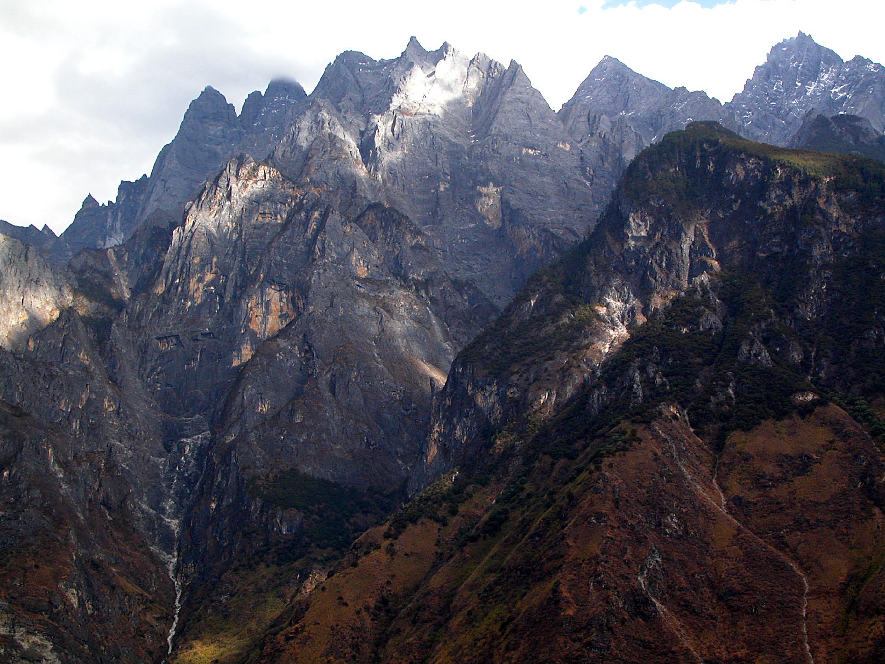
 Kuimen gate | |
 The course of the Yangtze River through China | |
| Yangtze River | |||
|---|---|---|---|
| Chinese name | |||
| Traditional Chinese | 長江 | ||
| Simplified Chinese | 长江 | ||
| Literal meaning | The Long River | ||
| |||
| first alternative Chinese name | |||
| Traditional Chinese | 揚子江 | ||
| Simplified Chinese | 扬子江 | ||
| |||
| Tibetan name | |||
| Tibetan | འབྲི་ཆུ་ | ||
| |||
The Yangtze, Yangzi or Cháng Jiāng ( /ˈjæŋtsi/ or /ˈjɑːŋtsi/; [jǎŋtsɯ́]) is the longest river in Asia, and the third-longest in the world. It flows for 6,418 kilometres (3,988 mi) from the glaciers on the Tibetan Plateau in Qinghai eastward across southwest, central and easternChina before emptying into the East China Sea at Shanghai. It is also one of the biggest rivers by discharge volume in the world. The Yangtze drains one-fifth of China's land area and its river basin is home to one-third of China's population.[6]
Along with the Yellow River, the Yangtze is the most important river in the history, culture and economy of China. The prosperous Yangtze River Delta generates as much as 20% of China's GDP. The river is an important physical and cultural dividing line between North and South China. The Yangtze River flows through a wide array of ecosystems and is itself habitat to several endemic and endangered species including the Yangtze River dolphin (now extinct), Chinese alligator, and the Yangtze sturgeon. For thousands of years, man has used the river for water, irrigation, sanitation, transportation, industry, boundary-marking and war. The Three Gorges Dam on the Yangtze River is the largest hydro-electric power station in the world.[7][8]
In recent years, the river has suffered from industrial pollution, agricultural run-off, siltation, and loss of wetland and lakes, which exacerbates seasonal flooding. Some sections of the river are now protected as nature reserves. A stretch of the Yangtze flowing through deep gorges in western Yunnan is part of the Three Parallel Rivers of Yunnan Protected Areas, a UNESCO World Heritage Site.
Names


Yangtze River, also spelled Yangtse River, Yangzi River and Yangtze Kiang, is derived from Yangzi Jiang listen (help·info), the local name for a stretch of the lower Yangtze near Yangzhou. “Yangzi” was the name of a village and site of an ancient ferry crossing, and Jiang is one of the Chinese words for river.[9] In the 13th century, the famous Song Dynasty official, Wen Tianxiangpenned a poem entitled Yangzi Jiang. Later, Western missionaries heard the name and applied it to the entire river.
[edit]Chinese names
During pre-Imperial times, the Chinese name for the river was simply Jiang (江, Old Chinese *kroong), possibly a loan word fromAustro-Asiatic languages. By the Han Dynasty, the term Jiang was already applied to other large waterways. The modern term Chang Jiang (长/長江), with Chang (长/長, "long") as the modifier has been in use since the Six Dynasties period.
The Chinese also use distinct names for different stretches of the river.
- Stretches of Chang Jiang have local names such as the Chuanjiang (川江, for the Sichuan portion of the river from Yibin toYichang), Jingjiang (荆江, for the Jingzhou section of the river) and Yangzi Jiang (near Yangzhou). The entire Chang Jiang is navigable and also known as the Golden Waterway.
- Jinsha River or Gold Sands River (金沙江 Jīnshā Jiāng, lit. "Golden Sands River") refers to 2,308 km of the Yangtze upstream from Yibin to the confluence with the Batang River, nearYushu.
- Tongtian River (通天河, lit. "river passing through heaven") refers to the 813 km stretch of the Yangtze from Yushu upstream to the confluence of the Tuotuo River and Dangqu, which together forms the Tongtian.
- Tuotuo River (沱沱河) refers to one of the headwater streams of the Yangtze. It arises from glaciers south of the Geladandong Mountain in Qinghai and flows west for 343 km where it meets with the Dangqu and forms the Tongtian.
[edit]Tibetan names
| This section does not cite any references or sources. Please help improve this section by adding citations to reliable sources. Unsourced material may be challenged and removed.(January 2011) |
The source and upper reaches of the Yangtze are located in ethnic Tibetan areas of Qinghai.[10] In Tibetan, the headwater streams of the Tuotuo are called Naqinqu. The Tuotuo River is known in Tibetan as Maqu (Red River). Tuotuo is derived from the Mongolian name for the river,Tuoketuonaiwulanmulun (托克托乃乌兰木伦, or the frothy red river). The Tongtian is known in Tibetan as the Drichu (Tibetan: འབྲི་ཆུ་ [11]; Wylie:'bri chu,直曲, lit. "river of the female yak"). Dangqu (当曲) another leading headwater stream of the Yangtze is Tibetan for "marsh river".
[edit]Geography
The river originates from several tributaries, two of which have claims to be the source. The Chinese government has recognized the source of the Tuotuo tributary at the base of a glacier lying on the west of Geladandong Mountain in the Dangla Mountain Range on the eastern part of the Tibetan plateau. However, the geographical source (i.e., longest river distance from the sea) lies in wetlands at N32˚36’14” E94˚30’44 and 5170 meters above sea level at the head of the Dan Qu tributary [[12]]. These tributaries join and the river then runs eastward through Qinghai, turning southward down a deep valley at the border of Sichuan and Tibet to reach Yunnan. In the course of this valley, the river's elevation drops from above 5000 m to less than 1000 m. The headwaters of the Yangtze are situated at an elevation of about 4,900 m (16,100 ft). In its descent to sea level, the river falls to an altitude of 305 m (1,001 ft) at Yibin, Sichuan Province, the head of navigation for riverboats, and to 192 m (630 ft) at Chongqing. Between Chongqing and Yichang (I-ch'ang), at an altitude of 40 m (130 ft) and a distance of about 320 km (200 mi), it passes through the spectacular Yangtze Gorges, which are noted for their natural beauty but are dangerous to shipping.
It enters the basin of Sichuan at Yibin. While in the Sichuan basin, it receives several mighty tributaries, increasing its water volume significantly. It then cuts through Mount Wushan borderingChongqing and Hubei to create the famous Three Gorges. Eastward of the Three Gorges, Yichang is the first city on the Yangtze Plain.
After entering Hubei, the Yangtze receives more water from thousands of lakes. The largest of these lakes is Dongting Lake, which is located on the border of Hunan and Hubei provinces, and is the outlet for most of the rivers in Hunan. At Wuhan, it receives its biggest tributary, the Han River, bringing water from its northern basin as far as Shaanxi.
At the northern tip of Jiangxi, Lake Poyang, the biggest freshwater lake in China, merges into the river. The river then runs through Anhui and Jiangsu provinces, receiving more water from innumerable smaller lakes and rivers, and finally reaches the East China Sea at Shanghai.

Four of China's five main freshwater lakes contribute their waters to the Yangtze River. Traditionally, the upstream part of the Yangtze River refers to the section from Yibin to Yichang; the middle part refers to the section from Yichang to Hukou County, where Lake Poyang meets the river; the downstream part is from Hukou to Shanghai. It is home to many thousands of people.
The origin of the Yangtze River is dated to about 45 million years ago in the Eocene,[13] but many people do not accept this point.[14]
[edit]Characteristics

The Yangtze flows into the East China Sea and was navigable by ocean-going vessels up a thousand miles from its mouth even before the Three Gorges Dam was built. As of June 2003, this dam spans the river, flooding Fengjie, the first of a number of towns affected by the massive flood control and power generation project. This is the largest comprehensive irrigation project in the world and has a significant impact onChina's agriculture. Its proponents argue that it will free people living along the river from floods that have repeatedly threatened them in the past and will offer them electricity and water transport—though at the expense of permanently flooding many existing towns (including numerous ancient cultural relics) and causing large-scale changes in the local ecology.
Opponents of the dam point out that there are three different kinds of floods on the Yangtze River: floods which originate in the upper reaches, floods which originate in the lower reaches, and floods along the entire length of the river. They argue that the Three Gorges dam will actually make flooding in the upper reaches worse and have little or no impact on floods which originate in the lower reaches. Twelve hundred years of low water marks on the river were recorded in the inscriptions and the carvings of carp at Baiheliang, now submerged.
The Yangtze is flanked with metallurgical, power, chemical, auto, building materials and machinery industrial belts and high-tech development zones. It is playing an increasingly crucial role in the river valley's economic growth and has become a vital link for international shipping to the inland provinces. The river is a major transportation artery for China, connecting the interior with the coast.
The river is one of the world's busiest waterways. Traffic includes commercial traffic transporting bulk goods such as coal as well as manufactured goods and passengers. Cargo transportation reached 795 million tons in 2005.[15][16] River cruises several days long, especially through the beautiful and scenic Three Gorges area, are becoming popular as the tourism industry grows in China.
Flooding along the river has been a major problem. The rainy season in China is May and June in areas south of Yangtze River, and July and August in areas north of it. The huge river system receives water from both southern and northern flanks, which causes its flood season to extend from May to August. Meanwhile, the relatively dense population and rich cities along the river make the floods more deadly and costly. The most recent major floods were the 1998 Yangtze River Floods, but more disastrous were the 1954 Yangtze River Floods, killing around 30,000 people. Other severe floods included those of 1911, which killed around 100,000, 1931 (145,000 dead), and 1935 (142,000 dead).
The Yangtze is very polluted, especially in Hubei (Shashi District).
[edit]History
See also: China Station, The Sand Pebbles (film), USS Asheville (PG-21), Yangtze Patrol, and HMS Amethyst (F116)
The Yangtze River is important to the cultural origins of southern China. Human activity was found in the Three Gorges area as far back as 27 thousand years ago.[17] In the Spring and Autumn Period,Ba and Shu were located along the western part of the river, covering modern Sichuan, Chongqing and western Hubei; Chu was located along the central part of river, corresponding to Hubei, Hunan,Jiangxi and southern Anhui. Wu and Yue were located along the eastern part of the river, now Jiangsu, Zhejiang and Shanghai. Although theYellow River region was richer and more developed at that time, the milder climate and more peaceful environment made the Yangtze River area more suitable for agriculture.
From the Han Dynasty, the region of the Yangtze River became more and more important to China's economy. The establishment of irrigation systems (the most famous one is Dujiangyan, northwest of Chengdu, built during the Warring States period) made agriculture very stable and productive. By the Song dynasty, the area along the Yangtze had become among the wealthiest and most developed parts of the country, especially in the lower reaches of the river. Early in the Qing dynasty, the region called Jiangnan (that includes the southern part of Jiangsu, the northern part of Zhejiang, and the southeastern part of Anhui) provided 1/3-1/2 of the nation's revenues.
The Yangtze has long been the backbone of China's inland water transportation system, which remained particularly important for almost two thousand years, until the construction of the national railway network during the 20th century. The Grand Canal connects the lower Yangtze with the major cities of the Jiangnan region south of the river (Wuxi, Suzhou, Hangzhou) and with northern China (all the way to Beijing). The less well known ancient Lingqu Canal, connecting the upper Xiang River with the headwaters of the Guijiang, allowed a direct water connection from the Yangtze Basin to the Pearl River Delta.[18]
Historically, the Yangtze became the political boundary between north China and south China several times (see History of China) because of the difficulty of crossing the river. This occurred notably during the Southern and Northern Dynasties, and the Southern Song. Many battles took place along the river, the most famous being the Battle of Red Cliffs in 208 AD during the Three Kingdoms period.
Politically, Nanjing was the capital of China several times, although most of the time its territory only covered the southeastern part of China, such as the Wu kingdom in the Three Kingdoms period, the Eastern Jin Dynasty, and during the Southern and Northern Dynasties and Five Dynasties and Ten Kingdoms periods. Only the Ming occupied most parts of China from their capital at Nanjing, though it later moved the capital to Beijing. The ROC capital was located in Nanjing in the periods 1911-12, 1927–37, and 1945-49.

[edit]Early history
Main article: Steamboats on the Yangtze River
The first merchant steamer in China, the Jardine, was built to order for the firm of Jardine Matheson in 1835. She was a small vessel intended for use as a mail and passenger carrier between Lintin Island, Macao and Whampoa. However, after several trips, the Chinese authorities, for reasons best known to themselves, prohibited her entrance into the river. Lord Palmerston, the British Foreign Secretary who personified gunboat diplomacy, decided to wage war on China mainly on the "suggestions" of Jardine Matheson[citation needed]. In mid-1840, a large fleet of warships appeared on the China coast, and with the first cannon fire aimed at a British ship, the Royal Saxon, the British started the First Opium War. British warships destroyed numerous shore batteries and Chinese warships, laid waste to several coastal forts, indiscriminately bombarding town after town with heavy cannon fire, even pushing up north to threaten the Imperial Palace in Beijing itself. The Imperial Government, forced to surrender, gave in to the demands of the British. British military superiority was clearly evident during the armed conflict. British warships, constructed using such innovations as steam power combined with sail and the use of iron in shipbuilding, wreaked havoc on coastal towns; such ships (like the Nemesis) were not only virtually indestructible but also highly mobile and able to support a gun platform with very heavy guns. In addition, the British troops were armed with modern muskets and cannons, unlike the Qing forces. After the British took Canton, they sailed up the Yangtze and took the tax barges, a devastating blow to the Empire as it slashed the revenue of the imperial court in Beijing to just a small fraction of what it had been.
In 1842, the Qing authorities sued for peace, which concluded with the Treaty of Nanjing signed on a gunboat in the river, negotiated in August of that year and ratified in 1843. In the treaty, China was forced to pay an indemnity to Britain, open five ports to Britain, and cede Hong Kong to Queen Victoria. In the supplementary Treaty of the Bogue, the Qing empire also recognised Britain as an equal to China and gave British subjects extraterritorial privileges in treaty ports.
[edit]U.S. and French conflicts
The US, at the same time, wanting to protect its interests and expand trade, ventured the USS Wachusett six-hundred miles up the river to Hankow in about 1860, while the USS Ashuelot, a sidewheeler, made her way up the river to Ichang in 1874. The first USS Monocacy, a sidewheel gunboat, began charting the Yangtze River in 1871. The first USS Palos, an armed tug, was on Asiatic Station into 1891, cruising the Chinese and Japanese coasts, visiting the open treaty ports and making occasional voyages up the Yangtze River. From June to September 1891, anti-foreign riots up the Yangtze forced the warship to make an extended voyage as far as Hankow, 600 miles upriver. Stopping at each open treaty port, the gunboat cooperated with naval vessels of other nations and repairing damage. She then operated along the north and central China coast and on the lower Yangtze until June 1892. The cessation of bloodshed with the Taiping Rebellion, Europeans put more steamers on the river. The French, not to sit idle and get rice crumbs, engaged the Chinese in war over the rule of Vietnam. The Sino-French Wars of the 1880s emerged with the Battle of Shipu having French cruisers in the lower Yangtze.

The China Navigation Company was an early shipping company founded in 1876 in London, initially to trade up the Yangtze River from their Shanghai base with passengers and cargo. Chinese coastal trade started shortly after and in 1883 a regular service to Australia was initiated. Most of the company's ships were seized by Japan in 1941 and services did not resume until 1946. Robert Dollar was a later shipping magnate, who became enormously influential moving Californian and Canadian lumber to the Chinese and Japanese market.
Yichang or Ichang, 1,600 km (990 mi) from the sea, is the head of navigation for river steamers; oceangoing vessels may navigate the river toHankow, a distance of almost 1000 km (almost 600 mi) from the sea. For about 320 km (200 mi) inland from its mouth, the river is virtually at sea level.
The Chinese Government, too, had steamers. It had its own naval fleet, the Nanyang Fleet, which fell prey to the French fleet. The Chinese would rebuild its fleet, only to be ravaged by another war with Japan (1895), Revolution (1911) and ongoing inefficiency and corruption. Chinese companies ran their own steamers, but were second tier to European operations at the time.
[edit]
Steamers came late to the upper river. The three gorges and the strong current hindered plans. Achibald Little attempted a voyage with the Lee-Chuan, and the Kuling, delays and weak engines meant that he only succeeded in the first vessel in 1898. Little soon built the first truly successful boat, the Pioneer, about 1899 — she plied the river for two more decades and was even the flagship[citation needed] for the British Royal Navy on the China Station. There were a few commercial steamers on the upper river by the turn of the century and the Boxer Rebellion. The commercial firms of Jardine Matheson, Butterfield and Swire and Standard Oil had their own steamers on the river. Until 1881, the India and China coastal and river services were operated by several companies. In that year, however, these were merged into the Indo-China Steam Navigation Company Ltd, a public company under the management of Jardine's. The Jardine company pushed inland up the Yangtsze River on which a specially designed fleet was built to meet all requirements of the river trade. For many years, this fleet gave unequalled service. Jardine's established an enviable reputation for the efficient handling of shipping. As a result, the Royal Mail Steam Packet Company invited the firm to attend to the Agency of their Shire Line which operated in the Far East. Standard Oil ran the tankers Mei Ping, Mei An and Mei Hsia, which were all destroyed on December 12, 1937 when Japanese warplanes bombed and sank the U.S.S. Panay. One of the Standard Oil captains who survived this attack had served on the Upper River for 14 years.[19]
[edit]
With the Treaty Ports, the European powers and Japan were allowed to float navy ships into China's internal waters. The British, US and French did this. A full international fleet featured on Chinese waters: Austro-Hungarian, Portuguese, Italian, Russian and German navy ships came to Shanghai and the treaty ports. The Japanese engaged in open war with the Chinese twice, and Russians twice, over conquest of the Chinese Qing empire — in the First and Second Sino-Japanese War 1895, and 1905; and the Russo-Japanese War of 1904. Incidentally, both the French and Japanese navies were heavily involved in running opium and narcotics to Shanghai, where it was refined into morphine. It was then transhipped by liner back toMarseille and France (i.e. French Connection) for processing in Germany and eventual sale in the US or Europe.

In 1909 the gunboat USS Samar changed station to Shanghai, where she regularly patrolled the lower Yangtze River up to Nanking and Wuhu. Following an anti-foreign riots in Changsha in April 1910, which destroyed a number of missions and merchant warehouses, Samar sailed up the Yangtze River to Hankow and then Changsa to show the flag and help restore order. The gunboat was also administratively assigned to theAsiatic Fleet that year, which had been reestablished by the Navy to better protect, in the words of the Bureau of Navigation, "American interests in the Orient." After returning to Shanghai in August, she sailed up river again the following summer, passing Wuhu in June but then running aground off Kichau on 1 July 1911.
After staying stuck in the mud for two weeks, Samar broke free and sailed back down river to coal ship. Returning upriver, the gunboat reached Hankow in August and Ichang in September where she wintered over owing to both the dry season and the outbreak of rebellion at Wuchang in October 1911. Tensions eased and the gunboat turned downriver in July 1912, arriving at Shanghai in October. Samar patrolled the lower Yangtze after fighting broke out in the summer 1913, a precursor to a decade of conflict between provincial warlords in China. In 1919, she was placed on the disposal list at Shanghai following a collision with a Yangtze River steamer that damaged her bow.
The Spanish boats were replaced in the 1920s by the Luzon and Mindanao were the largest, Oahu and Panay next in size, and Guam andTutuila the smallest. China in the first fifty years of the 20th century, was in low-grade chaos. Warlords, revolutions, natural disasters, civil war and invasions contributed. Yangtze boats were involved in the Nanjing Incident in 1927 when the Communists and Nationalists broke into open war. The Chiang's massacre of the Communists in Shanghai in 1927 furthered the unrest, US Marines with tanks were landed. River steamers were popular targets for both Nationalists and Communists, and peasants who would take periodic pot-shots at vessels. During the course of service the second USS Palos protected American interests in China down the entire length of the Yangtze, at times convoying U.S. and foreign vessels on the river, evacuating American citizens during periods of disturbance and in general giving credible presence to U.S. consulates and residences in various Chinese cities. In the period of great unrest in central China in the 1920s, Palos was especially busy patrolling the upper Yangtze against bands of warlord soldiers and outlaws. The warship engaged in continuous patrol operations between Ichang and Chungking throughout 1923, supplying armed guards to merchant ships, and protecting Americans at Chungking while that city was under siege by a warlord army
The British Royal Navy had a series of Insect class gunboats which patrolled between Chongqing and Shanghai. Cruisers and destroyers and Fly class[citation needed] vessels also patrolled. The most infamous incident was when USS Panay and HMS Bee in 1937,were dive bombed by Japanese aeroplanes during the Nanking Massacre. The Europeans were forced to leave the Yangtse River with the Japanese takeover in 1941. The former steamers were either sabotaged or pressed into Japanese or Chinese service. Probably the most curious incident involved HMS Amethyst in 1949 during the Chinese Civil war between Kuomintang and People's Liberation Army forces; and led to the award of the Dickin Medal to the ship's catSimon. See the film Yangtse Incident starring Richard Todd.
[edit]Major cities along the river
See also: Category:Populated places on the Yangtze River


- Panzhihua
- Yibin
- Luzhou
- Chongqing
- Yichang
- Jingzhou
- Shashi
- Shishou
- Yueyang
- Xianning
- Wuhan
- Ezhou
- Huangshi
- Huanggang
- Chaohu
- Chizhou
- Jiujiang
- Anqing
- Tongling
- Wuhu
- Hefei
- Chuzhou
- Maanshan
- Taizhou
- Yangzhou
- Zhenjiang
- Nanjing
- Jiangyin
- Nantong
- Shanghai
- Fengdu
[edit]Crossings
Main articles: Yangtze River bridges and tunnels and Yangtze River Power Line Crossings
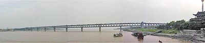
Until 1957, there were no bridges across the Yangtze River from Yibin to Shanghai. For millennia, travelers crossed the river by ferry. The river stood as a major geographic barrier dividing northern and southern China. In the first half of the 20th century, rail passengers from Beijing to Guangzhou and Shanghai had to disembark, respectively, at Hanyang and Pukou, and cross the river by steam ferry before resuming journeys by train. After the founding of the People's Republic in 1949, Soviet engineers assisted in the design and construction of theWuhan Yangtze River Bridge, a dual-use road-rail bridge, built from 1955 to 1957. It was the first bridge across the Yangtze River. The second bridge across the river was built a single-track railway bridge built upstream in Chongqing in 1959. The Nanjing Yangtze River Bridge, also a road-rail bridge, was the first bridge to cross the lower reaches of the Yangtze, in Nanjing. It was built after the Sino-Soviet Split and did not receive foreign assistance. Road-rail bridges were then built in Zhicheng (1971) and Chongqing (1980).
Bridge-building slowed in the 1980s before resuming in the 1990s and accelerating in the first decade of the 21st century. The Jiujiang Yangtze River Bridge was built in 1992 as part of the Beijing-Jiujiang Railway. A second bridge in Wuhan was completed in 1995. By 2005, there were a total of 56 bridges and one tunnel across the Yangtze River between Yibin and Shanghai. These include some of the longest suspension and cable-stayed bridges in the world on the Yangtze Delta: Jiangyin Suspension Bridge (1385m, opened in 1999), Runyang Bridge (1490m, opened 2005), Sutong Bridge (1088m, opened 2008). The rapid pace of bridge construction has continued. The city of Wuhan now has six bridges and one tunnel across the Yangtze.
A number of power line crossings have also been built across the river.
- Bridges over the Yangtze


[edit]Dams


As of 2007, there are two dams built on the Yangtze river: Three Gorges Dam and Gezhouba Dam. Several dams are being constructed on the upper portion of the river, the Jinsha River.
[edit]Tributaries

The Yangtze River has over 700 tributaries. The major tributaries (listed from upstream to downstream) with the locations of where they join the Yangtze are:
- Yalong River (Yunnan Province)
- Min River (Yibin, Sichuan Province)
- Jialing River (Chongqing)
- Wu Jiang
- Qing Jiang (Yidu, Hubei Province)
- Yuan River
- Zi Shui
- Xiang River(Yueyang, Hunan)
- Han River (Wuhan, Hubei)
- Gan River (near Jiujiang, Jiangxi Province.)
[edit]Protected areas
- Sanjiangyuan ("Three Rivers' Sources") National Nature Reserve in Qinghai
- Three Parallel Rivers of Yunnan
[edit]Wildlife
The Yangtze is home to at least three critically endangered species: The Chinese Alligator, the Finless Porpoise and the Chinese Paddlefish. (This is the only other place besides the U.S. that is native to an alligator and paddlefish species.) The Finless Porpoise were counted in 2010 to be 1000 exemplars. More species have become extinct in the Yangtze than in any other river in China.[citation needed] This is due to commercial use of the river coupled with tourism and pollution. In December 2006, the Baiji (Chinese River Dolphin) was declaredfunctionally extinct after an extensive search of the river revealed no signs of the dolphin's inhabitance; however, one was sighted soon after.[20]
0 comments:
Post a Comment